The observations that we did were about the properties of water and what are they. The properties consist of a negative charge and two positive charges.
The prediction that I thought of was that the polar molecule would be destroyed when it flows down something or is desroyed by other molecules.
The outcome of the procedure was that the polar molecules stayed together and actually made bonds with other molecules.
This happened beacause the one of the positive charges and one of the negative charges of another polar molecule got attracted together. The polar molecule stayed together because they would not break their bonds with another polar molecule. Bonds tend to form and disconnect very often.
Monday, May 11, 2009
Friday, May 8, 2009
Last Blogpost

This is a polar molecule.

A pic of plate tectonics.

A picture of a volcano.
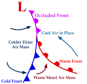
A picture of different fronts.

A nebula.
The last blog post that I will make is right here. The things I'm going to talk about is what were my favorite topics in lessons from Science class.
In Astronomy, my favorite topic that we went over was when we were studying astronomers that thought what the solar system was formed like. When we were studying about astronomy, I liked what I found out about other ways to look at the solar systems or nebulas.
In Weather and Climate (Earth's Atmosphere), my favorite topic was when we studied about weather fronts. When we were studying about weather fronts, I finally knew what the curve and arrows or half circle meant on a weather channel.
In Geology, I liked the volcano field trip. When we were studying volcanoes, the volcano from the inside became more clearer than what I studied back in 3rd grade.
In Weathering and Erosion, I liked when we studied plate tectonics. The plate tectonics are the plates that are under the ocean and make earthquakes.
In Earth's Water's, I liked to find out about what are polar molecules. The polar molecule is a molecule that is made up of two positive charged and one negative charged particle.
Thursday, April 30, 2009
Where Does Colorado Springs Water Come From
About 75% of the water that Colorado Springs uses is from mountain springs in the areas of Aspen, Leadville, and Breckenridge-Colorado. Protective pipes transfer this water down from the mountains to be stored in local reservoirs like Rampart Reservoir and Catamount Reservoir.
Rampart Reservoir is a 500 surface acre lake located between the United States Air Force Academy and Woodland Park-nestled in the middle eastern slope of the Rocky Mountains. Catamount Reservoir is a 210 surface acre lake on the North Slope of Pikes Peak.
Rampart Reservoir is a 500 surface acre lake located between the United States Air Force Academy and Woodland Park-nestled in the middle eastern slope of the Rocky Mountains. Catamount Reservoir is a 210 surface acre lake on the North Slope of Pikes Peak.
Monday, April 20, 2009
Penny Lab
The Penny Lab is an activity to see how many water droplets can go on top of a penny without the water coming off the penny.
I thought that there would only be 4 water droplets that would be able to get onto the penny.
I found out that 9 water droplets could go on top of the penny without it coming off.
The water molecules inside the water droplets were constantly breaking apart with their positive and negative charge. Also, water molecules were bulding up inside the water droplet, so it would eventually come off the penny.
Monday, March 30, 2009
Water

I am a tourist looking at dam. I'm at the Hoover Dam, between Nevada and Arizona on the Colorado River. The Hoover Dam is very large, about 1244 feet long and 726.4 feet high. The sight from the helicopter is great, you could see Lake Mead from where the helicopter flew over. Most of the sounds are water moving, cars, and helicopter. This dam revels that Earth's water is very unpredictable from the time that the Hoover Dam wasn't built to the time it was built. A relationship between humans and Earth's water is trying to learn more about the Hoover Dam. This large dam one of the largest dams in the world. Also the Hoover Dam is probably going to stay the longest to stay standing.
Thursday, January 22, 2009
Earthquake Webquest
1. Part A: Where plates meet.
Part B: In Western North America and Alaska.
2. It happens where the plates touch.
3. The place is called plate tectonics in the Atlantic Ocean.
4. 3 magnitude
Date-Time: Thursday, January 15, 2009 at 1:04:27 UTC
Location: 56.124°N, 135.609°W
Region: Southeastern Alaska
Distances: * 60 km (38 miles) WSW (258°) from Port Alexander, AK
* 108 km (67 miles) S (189°) from Sitka, AK
* 121 km (75 miles) W (278°) from Edna Bay, AK
* 991 km (616 miles) ESE (118°) from Anchorage, AK
5. 5 magnitude
Date-Time: Thursday, January 22, 2009 at 05:09:41 UTC
Location: 47.078°N, 155.499°E
Depth: 10 km (6.2 miles)
Region: East of the Kuril Islands
Distances: 405 km (250 miles) S of Severo-Kuril'sk, Kuril Islands, Russia
625 km (385 miles) ENE of Kuril'sk, Kuril Islands
1815 km (1130 miles) NE of TOKYO, Japan
7230 km (4490 miles) NE of MOSCOW, Russia
6. People can protect themselves from danger of earthquakes by: bolting their house to a good foundation, bolting bookshelves to a wall, strapping a water heater to a wall, have beams bolted tightly to each other, bolting a brick chimney securly, and having no heavy objects above a bed. Also, taking cover under a strong table or inside a bath.
Thursday, November 20, 2008
Voyages
Voyage 1
Trip Itinerary and approximate latitude: Havana, Cuba to London, England
Travel time: 9 Days
Direction traveling: North East
Were you successful? Yes
How many attempts? 3
How were you successful? Focused on winds and direction
What winds did you take advantage of or compete with during your travel? Prevailing Westerlies
Voyage 2
Trip Itinerary and approximate latitude: San Francisco, United States to Sydney, Australia
Travel time: 13 Days
Direction traveling: South West
Were you successful? Yes
How many attempts? 4
How were you successful? I payed attention to the winds
What winds did you take advantage of or compete with during your travel? I took advantage of the Trade Winds and competed with the Prevailing Westerlies
Voyage 3
Trip Itinerary and approximate latitude: Lima, Peru to Cape Town, South Africa
Travel time: 15 Days
Direction travelling: East
Were you successful? Yes
How many attempts? 2
How were you successful? Payed attention to winds and Straits of Magellan
What winds did you take advantage of or compete with during your travel? I took advantage of the Prevailing Westerlies
Subscribe to:
Posts (Atom)
